Wetlands – Our Hope, their future
Wetlands – Our Hope, their future
The Mid-Barataria Sediment Diversion Project
Blog by Al DuVernay III, Paleontologist, CRCL Volunteer
November 3, 2023
Millisecond by millisecond, day by day, eon by eon, she has drained much of the continent and simultaneously deposited land-building sediment and nutrients. The older upstream portion of the valley is mature hard ground suitable for roads, buildings, agriculture and a variety of human activities and enterprises. By contrast, the lower, youngest portion of this essential landscape is quite squishy and very fragile.
The river’s modus operandi is that it is continuously changing. Grain by grain, slurry of mud by slurry, she provides a substrate for a vast assemblage of flora and fauna to claim and thrive. A natural event like a storm or flood regularly occurs and destroys acres or perhaps millions of acres of this new terra (sub) firma. No matter. She instantaneously gets busy ruthlessly building toward the sea. Always toward the sea, nourishing wetlands and building land. These are our nation’s wetlands, and they are the cradle of life.
There is a new river diversion project proposal for the Barataria Basin in southeast Louisiana. The basin includes all of the land and wetlands on the west bank of the Mississippi River from Luling to Grand Isle. We have lost a tremendous amount of land in the basin over the decades, and we are continuing to lose it at an alarming rate. I have personal and intimate experience with the demise of our ecosystems — and equally with the tools and techniques used for restoration. The Environmental Impact Statement for the Mid-Barataria Sediment Diversion is a public document and is available on the Army Corps of Engineers’ website. Please read and understand it. Do it for our progeny. For our legacy.
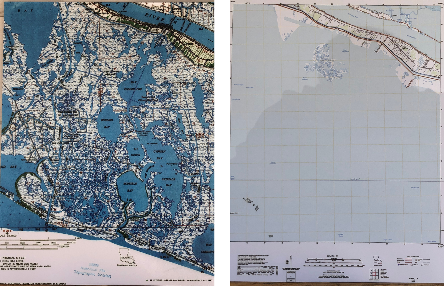
Land Loss in Louisiana
These maps, from the United States Geological Service, show wetlands around Buras in 1960 and open water in the same spot in 2020.
We also dug channels through the wetlands to improve conveyance of people and resources. Unfortunately, these canals accelerated saltwater intrusion and erosion. I will opine that early on, we mostly did all of this with honorable intent and innocent ignorance of the long-term effects.
In many ways, these landscape alterations enhanced our outdoor excursions in the short term. Where we used to catch bass and bream and catfish in St. Bernard Parish within the dead or dying cypress swamps, we now caught boxes full of speckled trout that we brought back to the launch.
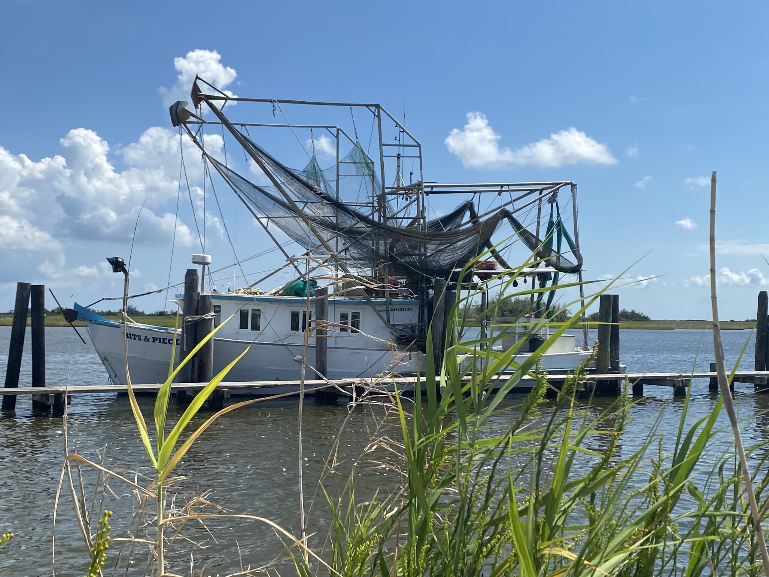
We know now, of course, that those short-term gains were just that. Short term. In addition to natural subsidence and compaction, turning off the sediment machine of the river with levees and digging channels through the marsh has obliterated a once healthy and thriving deltaic ecosystem beyond recognition. In the early 60s, with a good pair of shrimp boots, a well-planned route and an occasional knee-deep wade, a person could step off of the road in Buras and walk to the Gulf of Mexico. To get to the Gulf today from that same waypoint, you’ll be needing a good bay boat. Furthermore, you’ll not encounter a single blade of marsh grass in your 8-mile or so tour (see photos).
We have many tools at our disposal for restoring and mitigating and rebuilding. We’ve been employing some of these tools for a long time, so we know what works and what doesn’t. We’ve dredged sand from offshore shoals to rebuild barrier islands and ridges. We’ve dredged and transported bay sediment to recharge dying marshlands and land bridges. We’ve reconnected the river to the wetlands in order to semi-replicate the natural land building and nourishment processes. We’ve done native grass and tree plantings, dune building and living reef construction. All of these tools are valid, effective and essential. Know, however, that each tool is effective for specific objectives, and no one tool is well suited for all of our needs.
In 1972 I built a camp with my best friend in the upper Barataria Basin near Lake Salvador, just south of the current Davis Pond diversion. The 1970s were my college and early professional life years during which I learned my trade as a sedimentary geologist and paleontologist. It was then that I became aware of and intimate with the mechanics of our ecosystems. It was then that I learned of the methodical and unrelenting demise of our coastal environment; of the merciless disappearance of marshlands and islands; of the steady encroachment of salt water. Over the years, I observed the relentless mutation at our camp on Bayou des Allemands from a near pristine freshwater environment to one of more saltwater influence and less marshland. Where we used to exclusively catch freshwater species (bass, bream and freshwater cats), we started catching more saltwater species (specs, reds, hardhead cats). The ecologic and environmental transfiguration was stark. Even the bugs changed. For the worse.
I recently toured the Davis Pond area. I walked on flotant marsh and hard-ground willow tree forest that just a few years ago was open water. It’s working beyond my wildest dreams.
I’ve had discussions with commercial and recreational outdoorsmen, and a common dialogue is that “my daddy fished here, and his daddy fished here and his … .” Actually, that’s not completely accurate. I’m as old as their grandad. I couldn’t drag my shrimp net, nor collect oysters on that reef nor pop a fishing cork there, because that was not open water. It was marsh land and splendid tidal channels and ponds and bays. Your grandad and I had fished/worked south of there, where the habitats were suitable and productive.
It is our own actions that have caused the fabric of the life we love to unravel like a nickel mop in a rainstorm. By our own actions, we can repair and rebuild it. My vision for the future of our coast looks much like the coast that I grew up in. That’s a legacy I will be proud of.
The Barataria Basin is vast and vital as a storm buffer; for human and wildlife habitat; to our culture and economy; but, through our actions and neglect, it has steadily disappeared. Both the demise and successful restorations of wetlands are apparent and abundant as are the challenges. I have lived through many of these changes and faced their difficulties, yet my hope endures. Restoration will require great effort, determination and yes, sacrifice, but we must make the hard choices for our progeny, for our legacy. Or not and lose it completely.
THANK YOU, AL DUVERNAY III, PALEONTOLOGIST, CRCL VOLUNTEER AND COASTAL ADVISORY COUNCIL MEMBER.